Archive for June, 2010

State of the state parks

Monday, 28th June 2010; 8:13 pm - Location:

There’s an article in today’s Detroit Free Press about Michigan’s state parks. It doesn’t paint a rosy picture, pointing out that many state parks across the country are closing, and that they’re all facing funding problems. Michigan’s parks no longer receive any tax-based funding, relying entirely on the fees they charge the people (such as I) who visit them and camp at them. They’re postponing repairs and updates, cutting back on expenses, and getting by with less staff.

But there’s good news in the article. None of Michigan’s parks have been closed. This is especially good news to me, because I’m rather fond of the smaller, more remote parks that would be the first to close if that had to happen. In fact, with people unable to afford trips overseas or even out of state, the parks are getting used more. And there are plans to improve Michigan parks funding by offering a less expensive day-use pass for the parks to all motorists in the state, which would spread the support costs around farther. So I’m hopeful that I’ll be able to keep taking scooter-and-parks trips like this for years to come.

Tech for the trek

Thursday, 24th June 2010; 4:07 pm - Location:

I work with digital technology for a living, and it’s an integral part of my life. So when I started planning my first scooter excursion last year, I had to decide what technology to bring along.

“None” was not an option. Even when I went backpacking in the wilderness, deliberately eschewing technology, I still had my analog wristwatch, my digital camera, and a cheap cellphone (for I-broke-my-leg use only, turned off and buried at the bottom of the pack). But last year’s big scooter trip wasn’t an exercise in survival or naturalism; technology has a legitimate place on the road. After all, the scooter itself is “high technology”… from a century ago.

I very briefly considered bringing a laptop. At the time (before it was stolen) I had a very slim and lightweight MacBook Air which I could have found room for. But it was “too much”. I didn’t need a machine I could run Photoshop and iTunes and OpenOffice on. I wanted to get away from that stuff for a week.

My iPhone (1st gen) was a much better match. I needed to bring a phone no matter what; scooting far from home and from town to town without one would be irresponsible. And it had just enough additional capabilities to handle the other things I’d still want technology for: navigational aids, weather info, and blogging the adventure. It could serve as a snapshot camera as well.

The only other high-tech gear I brought along was a friend’s GPS navigation unit, which I used only when I had a specific need for it: finding a gas station in the middle of nowhere when I was running on empty, or finding my way through downtown Green Bay with a minimum of fuss.

iPhone 4

iPhone 4

At the risk of turning this into an advert/testimonial: I just picked up the centerpiece of this year’s tech. It’s iPhone 4. (Note that I didn’t say “the iPhone 4″ or “an iPhone 4″. Apple promotional literature refers to the device without any articles at all, as if it were some kind of abstract Platonic ideal. It’s simply “iPhone 4”. 🙂 )

I never upgraded to iPhone 3G or 3GS; they didn’t offer enough new to compel me to upgrade, and they’d cost an additional $20/month more than the bare-minimum pre-paid plan available for the original model. But now that AT&T is offering some more affordable iPhone data plans (for the people who aren’t overburdening their network), I can justify spending a couple hundred bucks on a new phone.

This new model includes GPS and a compass, so with the addition of an app from the App Store, I won’t need a separate GPS navigation device. It has a much better camera, with higher resolution and a focusing lens… but it only has “digital zoom” (which is a gimmick), so it’s still not good enough to get me go without the “serious” camera and its real 20X optical zoom. But I can use it as a replacement for the “backup” camera I brought along last year. It even has a built-in flashlight! And of course iPhone 4 will do everything iPhone 1 did, including the ability to blog the trip. It’s not just a phone; it’s a Swiss Army phone. If only it included a corkscrew….

So ultimately I won’t be carrying any more items of technology than I do on my wilderness backpacking trips: my watch, my camera, and my phone. It’s just that the phone is going to be quite a bit more functional – and quite a bit more-often used – than the little phone I’d shove to the bottom of my backpack.

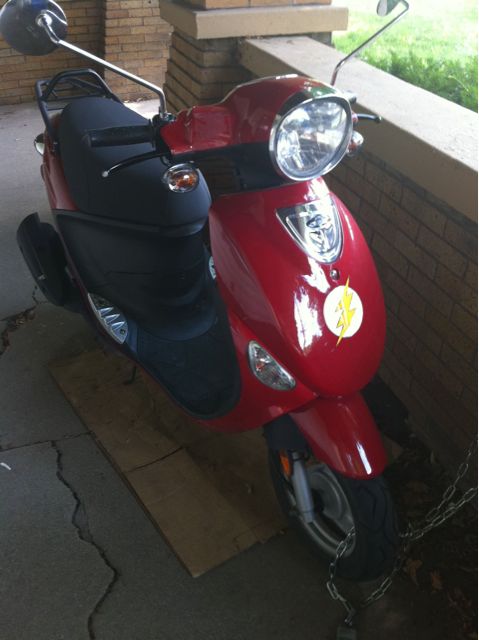
To give you a sense of the camera quality, here’s a snapshot of Flash.
Where to go… what to do…

Monday, 14th June 2010; 9:32 am

The overall route is set, but that’s a far cry from having the whole trip planned. There are roads to select, sights and sites to choose, and so on. So I’ve been doing some work on that.

MotorcycleRoads.US is a nice source of tips for specific roads to ride. Last year the site tipped me off to the “Tunnel of Trees” on M-119 along the lakeshore between Little Traverse Bay and Mackinac, which I might have missed otherwise, because on a map it looks like just taking the long way.

The relevant recommendations for this year’s part of the state are more general, basically endorsing the entire lakeshore route from Mackinac to Lake St Clair. 🙂 (It also suggests a route that could be great for one of my future rides, thru inland northern Michigan.)

My initial thoughts for how to spend my full day camped at Cheboygan State Park revolved around revisiting places I’d been before: re-riding the Tunnel of Trees in the other direction, or spending more time on Mackinac Island. But I’ve decided to focus instead on Bois Blanc Island (“Boblo” to the locals), the larger neighbor of Mackinac. It’s less developed and touristic, but it does allow motor vehicles, so I could spend a day there. Unfortunately it doesn’t look like it has a road along the entire shoreline, which would’ve allowed for a straightforward “ride around the island” excursion, but I’ll figure something out.

I’ll have a similar situation at the other end of the coastline, where I’ll be camping two consecutive nights pretty close together (about 60 miles). That gives me most of a day for a trip into Ontario and back. On the shore of Lake Erie, there’s Rondeau Provincial Park and Point Pelee National Park, both popular birdwatching sites, which means they’re probably good spots for a photo expedition. I’ll probably have to pick one or the other, however.

Where to go… what to do…

Monday, 14th June 2010; 9:32 am - Location:

The overall route is set, but that’s a far cry from having the whole trip planned. There are roads to select, sights and sites to choose, and so on. So I’ve been doing some work on that.

MotorcycleRoads.US is a nice source of tips for specific roads to ride. Last year the site tipped me off to the “Tunnel of Trees” on M-119 along the lakeshore between Little Traverse Bay and Mackinac, which I might have missed otherwise, because on a map it looks like just taking the long way.

The relevant recommendations for this year’s part of the state are more general, basically endorsing the entire lakeshore route from Mackinac to Lake St Clair. 🙂 (It also suggests a route that could be great for one of my future rides, thru inland northern Michigan.)

My initial thoughts for how to spend my full day camped at Cheboygan State Park revolved around revisiting places I’d been before: re-riding the Tunnel of Trees in the other direction, or spending more time on Mackinac Island. But I’ve decided to focus instead on Bois Blanc Island (“Boblo” to the locals), the larger neighbor of Mackinac. It’s less developed and touristic, but it does allow motor vehicles, so I could spend a day there. Unfortunately it doesn’t look like it has a road along the entire shoreline, which would’ve allowed for a straightforward “ride around the island” excursion, but I’ll figure something out.

I’ll have a similar situation at the other end of the coastline, where I’ll be camping two consecutive nights pretty close together (about 60 miles). That gives me most of a day for a trip into Ontario and back. On the shore of Lake Erie, there’s Rondeau Provincial Park and Point Pelee National Park, both popular birdwatching sites, which means they’re probably good spots for a photo expedition. I’ll probably have to pick one or the other, however.

Itinerary

Thursday, 10th June 2010; 3:33 pm - Location:

I’ve made reservations at all of the state parks (and one recreation area) I’ll be sleeping at along the way.

What’s annoying is that the state charges an $8 reservation fee for each one. If I’d simply booked a site at a single campground for a week, the fee would be $8 total. But because I reserved sites at six different campgrounds, it’s $48. That’s in addition to the fees for each site itself (which range from $18-$27 per night for a single person in a single tent), and the $24 annual pass for my vehicle. So the parks add up to $236, or nearly $34/night. Still cheaper than motels, though.

Another annoyance is that they won’t let you reserve just a Friday night or just a Saturday night. If you want one, you have to reserve both. Because of this, I had to schedule my ride so that I’d be someplace when I got to the weekend where I actually wanted to spend two nights, which is why I’m leaving on a Thursday and my last night is a Wednesday.

Anyway, without further ado, here’s the itinerary:

  • North Higgins State Park, in the middle of northern Michigan. Back in college, a couple friends and I had car trouble on a road trip to Mackinac, and very nearly got stuck for the weekend here in Roscommon instead. (I’m sure it’s very nice.)
  • Cheboygan State Park, on Lake Huron, first city to the east of Mackinaw. This will be my two-night stay, giving me time to visit Mackinac and/or Bois Blanc Island, or something else in the area.
  • Tawas Point State Park, along the state’s index finger on a promontory nearly encircling a small bay. This will be the first of three days along the Huron coast itself.
  • Albert E. Sleeper State Park, near the tip of the thumb. This day will be a ride around Saginaw Bay, through Bay City.
  • Algonac State Park, just north of Lake St Clair. I’ll follow Lake Huron to Port Huron, then follow the St Clair River.
  • Metamora-Hadley State Recreation Area, east of Flint. From Algonac I plan to take a day trip into Ontario, to Lake Erie, then turn back. M-H is a short distance west of Algonac, mostly to shorten the following day’s ride.
  • Grand Rapids, home. I’ll detour around Flint then head west.

This is one day shorter than my planned itinerary last year, which (at the time) I felt was about a day longer than I really wanted to be out on the road. Unlike last time, if at any point I just don’t feel like staying out any longer, on just about any morning of this trip – except the two in Cheboygan – I’ll be within 5-6 hours’ ride of home, so I could bail out at any time. Not that I expect that to happen.

Dream of the Blue Huron

Wednesday, 9th June 2010; 8:12 am - Location:

Last summer was my first on a scooter.

When I got “Flash” (my Genuine Scooters 50cc Buddy) I started with short rides around the neighborhood, then took some rides a few miles out of town, worked my way up to a 100-mile day trip to Lake Michigan and back, then went on an overnight camping trip down by the Indiana border, followed by an overnight just outside of Hell (near Brighton).

All of this was preparation for The Big Trip. It was a week on the scooter, exploring the north. I called it “a ride around Lake Michigan”, not because I actually went all the way around Lake Michigan, but because I spent most of it… “around Lake Michigan”. And I did go a large part of the way around: up the Lake Michigan coast to the Straits of Mackinac, across to Manistique, a side trip up to Pictured Rocks, then down the west side of the Lake as far as Manitowoc (near the city of Green Bay), then took the ferry across.

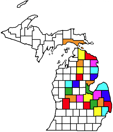
By this time I’d gotten the bug. As you can see from the multicolored map of Michigan at the top of the main page, I’ve been to more than two dozen counties in the state (plus a few in Wisconsin). And I began plotting (literally) additional road trips.

Last year I rode the entire length of the Michigan/Lake Michigan coast, from Indiana to Wisconsin. This year I’m going to do the Michigan/Lake Huron coast. Because I don’t live near that coast, that means I have a bit of a trip just to get to it, but that’s OK. It gives me a chance to cover some of the territory in between. So here’s the county map:
huronmap

That’s starting in Kent County (the red one in the lower left), up to the Straits of Mackinac at the top, then down around Saginaw Bay, around the Thumb to Lake St Clair (the “little Great Lake” north of Detroit), then back across to home. I’m deliberately taking a somewhat northern route for the last leg, to avoid duplicating a route I’ve already been through. This will add 23 counties to my tally.

I’ll be doing this a little earlier in the year this time (since I don’t have to wait for the vacation time to accrue): from 15-22 July. The vacation time is approved, and I’ve made reservations at five of the six state park/recreation-area campgrounds I’ll be staying at (I haven’t made up my mind about the last one).