Archive for August, 2017

Eclipse Plan B

Friday, 18th August 2017; 5:04 pm

The current forecast for Kentucky looks very good for Monday, the best it’s been!

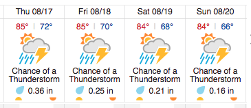
My biggest concern right now is Tuesday. The forecast for northern Indiana, which is where my itinerary says I’ll be Tuesday afternoon/evening, calls for almost certain thundershowers. That isn’t a deal-breaker, but it does make for a less pleasant trip.
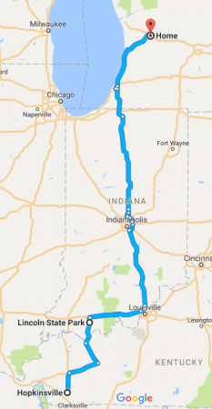
So I’ve been thinking about Plan B. Instead of two days of scooter riding in each direction, I could make the trip to the campsite I’ve reserved as my base at Lincoln State Park in southern Indiana, in a single day, by car. Then spend Monday getting to the eclipse and returning to base, and make the same one-day drive back on Tuesday. Google Maps says it’s 7 hours each way, so I’d assume 8 to allow for traffic.

There are a few disadvantages to doing the trip that way. 1) Driving is boring. 2) The car I’d take burns three times as much fuel. 3) If I got stuck in traffic, I wouldn’t be able to scoot around it. 4) I’d have to park the car when I got there, instead of being able to walk the scooter around with me or tuck it aside somewhere (which pretty well rules out going into Hopkinsville itself, which will be swamped).

But there are advantages to this approach: 1) It’d only be three days away from home, rather than five. 2) The car would be more comfortable, and let me bring more stuff, like my laptop. 3) Some of the cost of gas would be offset by not having to pay for campsites Saturday and Tuesday nights (which I haven’t reserved). And the big one: 4) The car is weatherproof.

I don’t need to make a decision until Saturday morning, which is the go/no-go time for doing it by scooter. I’ll check the forecasts again then, and make the choice.

Weather musing

Thursday, 17th August 2017; 10:26 am

It’s lousy weather for an eclipse here today: overcast with intermittent rain. The good news is that this isn’t when/where the eclipse is happening. The not-as-good news is that the forecast for west Kentucky/south Illinois is… pretty meh. Pretty low (but non-zero) chance of rain, and 50% cloud cover, give or take. Probably no rain on the ride down there, but probably some rain on the way home.

So here I sit like a Danish prince, debating whether to risk the slings and arrows of five days on the road for a 50% chance of seeing a total eclipse. It’s a decision I don’t have to make for a couple days… and as usual, that means I won’t.

Preparing for T-Mobile “coverage”

Monday, 14th August 2017; 9:13 pm

Ever since my first road trip in 2009, mobile phone coverage has been a challenge. In those days I had a first-generation iPhone with AT&T EDGE service. That trip went through the UP, where I sometimes had no signal at all, but could usually get a slow connection. A couple years later I upgraded to the iPhone 4, first with AT&T 3G service (which was pretty good), then switched to T-Mobile 3G (which was so bad up north that I bought a month of AT&T pre-paid just for the trip). With my iPhone 6, I switched to Verizon LTE for a couple years, which did alright, but now I’m back to T-Mobile (LTE), for the cost savings.

mapT-Mobile’s network is better than it was, but it still fails a lot outside of cities. I’ve checked their coverage map for Indiana and western Kentucky, and it’s pretty bad. The map, that is. It shows coverage as yes/no question, so looking at it gives you very little sense of the quality of coverage: it’s all solid magenta. The only way to get an assessment of quality is to click on specific locations, where it tells you things like “FAIR… works outdoors, sometimes in buildings”. And there are also areas I’m going through where they admit they don’t cover at all.
Fortunately I have one thing now that I didn’t have in olden days: offline maps. The standard Map apps on the old iPhone would cache map data whenever it was online, so it was possible with a little care and planning to load the data for the “dead” area you’d be visiting ahead of time. I used this trick pretty effectively when my cruise ship stopped on Curaçao – where I had no data access whatsoever – and I rented a scooter to ride the length of the island and back. But the cache was small and unstable; you couldn’t count on it to work for a long-distance trip. But the current Google Maps app for the iPhone has explicit support for offline mapping. It limits the area you can pre-download, but it allows you to save several of them, so I’ve downloaded maps to cover the entire route I’m planning.

This isn’t just to protect myself from T-Mobile’s poor coverage… it’s also to protect myself against T-Mobile’s poor customer service. I have a monthly allotment of 5GB of data on my plan, which should be easily enough for a trip like this. But the T-Mobile app on my phone can’t access my account information to tell me how much data I have left. I’ve been around and around with their customer service and tech support people trying to get it fixed, but… nope. There’s a technical problem at the root of it, but it’s one that could easily be circumvented by someone with a little authority who cared enough to say “Well, it won’t work that way, so let’s do it another way.” I have yet to find such a person.

Eclipse forecast improving

Monday, 14th August 2017; 9:08 am

Just a quick note that the forecast for the eclipse is improving. There’s a bit of rain expected in Kentucky later this week, but over the weekend the chance of rain drops off to negligible, and clouds are supposed to diminish, with about 15% cloud cover on the day of the eclipse. Still no guarantees of a good show, but if this is what the forecast looks like on Saturday morning, I’ll definitely make the trip as planned.

Solar photography practice

Friday, 11th August 2017; 12:13 pm

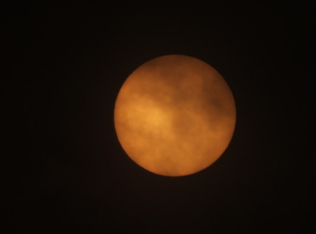
It’s a partly-cloudy day today, so we have an intermittent Full Sun for me to practice photographing. This was taken using my best camera, with the solar filter, at full zoom. A thin cloud was passing in front of the Sun, which is why it looks splotchy.

If a cloud passes in front of the Sun during the total eclipse, the disc will just vanish, and I won’t be able to see anything. All it would take is 2.5 minutes of cloud to spoil the entire photo opportunity on the 21st.

DSCF6068

Long-range eclipse forecast

Friday, 11th August 2017; 8:38 am

We’re getting close enough to the eclipse that the weather services are starting to offer forecasts. They aren’t great.

For Hopkinsville KY the four days before the eclipse, they’re projecting about a 60% chance of rain, and anywhere from 25-85% cloud cover at various times of day. That isn’t horrible. If that pattern continues for the day of the eclipse, there’d still be a fairly good chance of seeing totality. And even if it’s overcast and raining, the total eclipse will still happen: it will get dark in the middle of the day. But it would still be disappointing.

And conditions the days before and after matter too: I’m planning to be on the road and camping in a tent. Riding in the rain is no fun.

It’s still too early to be making any decisions based on this information. These 10-days-out forecasts are notoriously inaccurate, especially trying to differentiate between “probably cloudy” and “probably not cloudy”. It’s something I’m going to have to keep an eye on.

Screen Shot 2017-08-11 at 8.41.04 AM